Tuesday, 14 August 2007

Gorillas in the Mist!

Hello! We're back in Kampala, capital of Uganda after a short but amazing trip to view a family of mountain gorillas in their native jungle habitat. We weren't planning to do a gorilla trek, but events conspired against us in our efforts to reach Murchison Falls in the northern part of Uganda (details to be revealed in our next blog entry), so we headed south, first to a very relaxing camp on an island in Lake Bunyoni, then further south to see the gorillas.

Byoona Amagara resort was one of the most beautiful places we've visited in Africa. It's set on an island in the middle of a picturesque volcano crater lake, which required a one-hour paddle in a dugout canoe from the nearest road. All along the lake were lush, green, steep terraced hills, with fields of potatoes and other crops reaching up to the very tops of the hills. The best thing about this resort was the food - it was awesome! We had fresh talapia fish from the lake every night, mexican quesidillas for lunch, and potent rum balls for dessert - certainly not food we've seen anywhere else in Africa.


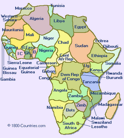
While at this resort we ran into a few people who had organized treks to view mountain gorillas. There's fewer than 700 mountain gorillas left in the wild (and none in captivity), all concentrated in the shared border area between Uganda, Rwanda and Democratic Republic of Congo (DRC, which was formerly known as Zaire). It's expensive and difficult to obtain a permit to view the gorillas in Uganda and Rwanda, but that isn't the case in DRC, where permits are readily available and cost substantially less money. There's not many tourists who want to venture into DRC, as it's just recovering from a decade-long civil war, but we'd heard it was relatively safe within DRC near the Ugandan border where the gorillas usually hang out. So we took a chance and booked a one-day trip into a country that, despite it's name, isn't very democratic, is barely a republic, but definitely is Congo! How could we resist?

Our day started very early as we piled into a pair of minivans with 20 Spanish tourists and drove an hour to the Uganda-DRC border. At the border we met a couple of Brits, Helen and Baz, with whom we spent the rest of our day gorilla treking with. Border formalities and briefings on do's and don'ts when meeting gorillas (including what to do when they charge at you!) took a couple of hours. We split up into groups of seven or eight people to visit five different families of gorillas. Finally we were off into Congo! The scenery was spectacular, the road was almost non-existent and it felt like we were in a very remote part of the world - definately Africa's Heart of Darkness.

After an hour of driving we continued on foot through fields of sorgum and potatoes and passed tiny mud thatched huts of the local Congalese. The locals were curious to see us and peered from their huts and from behind trees to say hello. After 2 1/2hrs of walking we reached the dense jungle of Parc des Virungas and started to see signs of the gorillas, they were close at hand our armed guides told us. Zoe's first sighting of a gorilla was a 200kg black back male gorilla charging towards her! A gorilla charging you in the DRC, unbelievable story but true! Fortunately the guides protected us and the gorilla was only marking his territory and letting us know who was in charge in his jungle. It was hard to crouch down in submission as we had been told rather than flee!

Visitors are limited to spending an hour with the gorillas. This passed very quickly but was an amazing and fascinating experience to see these wonderful animals in their natural setting and to get a taste of Diane Fossey's gorillas in the mist. The gorillas are quite playful and gentle and behaved a little like chimpanzees. The family we saw had 3 adolescent males and 2 infants who were very cute. The rangers told us that the mother had, unfortunately died and the infants were being looked after by the adolescent males.

Visiting the gorillas was icing on the cake for what has been so far
an already very good trip to Africa.

Like everything else in DRC: the size of the countryand it's primates,the beers are very large. Back at the border we celebrated seeing the gorillas with Helen & Baz by quaffing several of Congo's premier 720ml beers. The beer is called Primus which the Brits amongst us had a chuckle at as Primus is a make of British camp stove, so Primus beer must be good fuel!

Next is a few relaxing days on the beaches south of Mombasa before we fly home.

Sunday, 5 August 2007

Uganda - Mt Elgon and the River Nile

Hello from the source of the Nile! That would be in the town of Jinja just north of the equator on the shores of Lake Victoria and 6670km from where the Nile empties into the mediteranian sea.

We've been in Uganda for just over a week and it's rained everyday in their supposed dry season, even the Ugandans can't believe the weather!

We started our time in Uganda by climbing Mt. Elgon (4300m) on the border of Uganda and Kenya. This was a 4 day trip and again we hiked without porters, carrying all our own camping stuff. However we were obliged to have 2 armed ranger-guides with us. Our guides Sam & Patrick carried ancient wooden barreled rifles with them ostensibly to protect us from Kenyan poachers and cattle rustlers! However it is quite common place to see guards in town with such rifles outside banks & businesses so we're quite used to it now! Sam and Patrick were great company and always invited us to cook with them in their shelter and sit around the fire to chat, warm up & dry off.

The challenge on this mountain wasn't the altitude or cold but infact the mud. If the inuit have 30 words for snow, then the Ugandans must have 30 words for mud! The first day we climbed steeply up
on a muddy trail through villagers fields of bananas and maize and past their small tiny huts to the the Mt Elgon Park boundary to face "The Wall of Death". This is a cliff face with an even steeper and muddier trail that weaves through the cliff face. It was a relief to get to the top and enter the jungle like forest and slightly more level ground although the mud was just as bad! We camped in the forest under dripping trees in the rain.

The next day we continued up through the forest then through bamboo forest and eventually out into the sun and the mooreland where we camped for the second night. Next day was summit day we climbed up to the crater rim and walked around the rim to the highest point. We have obviously retained some acclimitisation from Mt. Kenya as even though we were up at 4300m, the walking was easy and fast. The caldera on Mt Elgon is huge and we had great views into the caldera full of lakes and giant groundsel.

We made a fast descent slipping and sliding down the mud and back to the regional town of Mbale for a celebratory Nile Special beer.

After climbing 4 mountains in a month , it was time for a rest. So we made our way to a remote island in the middle of the Victoria Nile to chill out. It was an epic journey there, from Mbale we took a bus, 2 shared taxis (14 seater minibuses with 22 people crammed in!), a 10km ride on the backs of scooters in torrential rain and finally a dug out canoe across the raging river! It was worth the effort to get to Hairy Lemon (yes that is the name of the place not our bad typing) as we had 3 great days of relaxation and eating 3 big meals a day. Until we arrived we didn't know it was a kayakers haven with 2 of the worlds most famous standing waves just down river, named after local beers! We will say this, kayakers like to party!

Tomorrow we are booked on a bus going to Rwanda but we're geting off just before the border at a place called Lake Bunyonyi near the town of Kabale.

Thanks for all the comments from our Mt Kenya blog!


Zoe and some of the Mt Elgon Rangers in the mooreland on the Sassa River route.


Chris hiking up through giant groundsel on the way to the crater rim on summit day.


Zoe on the summit of Mt Elgon, the Wagagi Peak at 4321meter


Ranger Sam and Chris holding the rifle on summit day with Jacksons Peak behind.


The gardens and restaurant at Hairy Lemon in the middle of the Victoria Nile.


Zoe relaxing on the verandah of our Banda at Hairy Lemon on an island in the middle of the Nile.


Wednesday, 25 July 2007

No Picnic on Mt. Kenya

"No Picnic on Mt. Kenya" is the title of one of the absolute classic mountaineering books. It's the true story of a couple of Italian prisoners of war during WWII, being held at a British POW camp in Kenya. Before the war they were climbers, and from their POW camp they can see Mt. Kenya. They spend weeks hoarding their rations, making crampons out of tin cans and doing gathering whatever pseudo mountaineering equipment they can find. Their only "map" is a photo of Mt. Kenya on the label of a can of corned beef. Then they break out of their camp and head to the mountain with the intention of climbing it...

Mt. Kenya is Africa's second-highest peak, and is located less than one degree south of the equator. Its two highest points, Nelion and Batian, are only accessible to rock climbers. We thought about bringing a rope and our climbing gear, but we thought that it wasn't worth lugging all that stuff around Africa for two months, when we'd only be using it for two days. And we couldn't find a reliable and inexpensive way of shipping our gear to Kenya. So, like 99% of the other people on the mountain, we settled for trekking to the third-highest peak, Pt. Lenana at 4985m, some 200m below the true summit. However, unlike most visitors to the mountain, we decided to do it without a guide or porters, (part of our penance of having the luxury of having them on Mt. Kilimanjaro). We also decided we'd do an east to west traverse of the mountain, starting in the village of Chogoria and ending some 85km later in the village of Naro Moru. So with huge packs full of clothes for wind, rain and cold, camping gear, and a week's worth of food, we set out. This was going to be "No Picnic on Mt. Kenya" for us, too!

Actually, the afternoon before we left we were rocked by an earthquake in Chogoria! After experiencing a magnitude 6.8 quake in Hawaii last October before Ironman, we're getting a bit tired of being hit by quakes every time we go on holiday! It's actually not too surprising we felt a quake here, as Chogoria is on the edge of the Rift Valley, and on the edge of a tectonic plate, where quakes are quite prevalent. We're taking our next holiday in the middle of a tectonic plate - Saskatchewan sounds good!

Our first day involved a 27km slog up a muddy track through dense jungle and then through bamboo forest. This would have been quite pleasant, except for the eight hours of rain we had during the hike! We were cold, tired and wet by the time we got to our camping spot. When we found that there were wooden cabins available, there was no question about camping - we opted for drying out and warming up by the fire in the cabin!

On the second day we hike 14km along a ridge. Unfortunately it was very misty so we only got the occasional tantalizing glimpse of the stunning views. But we were just happy it wasn't raining! As we reached our campsite for the night at Hall Tarns we climbed above the mist and were treated to spectacular mountain scenery.

We took a rest/acclimatization day at 4300m at Hall Tarn's and explored the surrounding area, including peering over the vertigo-inducing 300m cliff of The Temple down to one of Mt. Kenya's deep valleys.

The following day we climbed up steep scree and over Tooth Col at 4700m then across a precipitous scree slope to the Austrian Hut. We felt we were really in the mountains this day. It was cool hanging out at the Austrian Hut area as we'd read so much about it during our climbing days. The scenery was spectacular with the main summits just across the Lewis Glacier. We had to go and stand on a glacier at the equator!

Most people get up well before dawn to be at Pt. Lenana for sunrise. Having seen plenty of sunrises, we chose the civilized option and climbed in the light. It was much warmer and we had the summit to ourselves when we reached it at 8:00 a.m. We spent a glorious 30 minutes on the summit in cloudless, windless conditions admiring the views on all sides. Later that day we packed up our tent and descended 2000m down through the glacier-scoured Teleki Valley through forests of giant groundsel. We didn't quite escape the day without getting wet; as we descended the notorious "vertical bog" a hailstorm hit us and the bog turned into a river. This was a sting in the tail to a very long, tough day. Fortunately it cleared up within an hour and we had sunshine to finish the day.

The trek wasn't over yet; we had a further 23km to hike to the village of Naro Moru, however the going was much easier, most of it on a 4WD track (and in the sunshine!). We descended through bamboo and cloud forest where we saw plenty of fresh elephant and buffalo dung, but the animals remained elusive. When we reached our hotel in Naro Moru we celebrated with huge plates of chips and cold Tusker beers. Tired, stiff and a little sunburned, we felt like we'd just done an Ironman! This trip was way harder than climbing Mt. Kilimanjaro but it felt much more rewarding. No picnic indeed!

Next stop, Uganda!

Our campsite nestled among the Giant Groundsel by Hall Tarn (4300m). The spires of Mt Kenya ridges behind. Finally some clear sunny weather!

You can just make out Chris on top of the cliff of the Temple along the Chogoria route on the slopes of Mt Kenya.


Chris at our campsite at the Austrian Hut (4800m) with the summit spires Nelion and Batian of Mt Kenya behind.


Glacier at the equator! Zoe on Lewis Glacier (4800m) below Nelion spire on Mt Kenya.


Zoe & Chris with the Kenyan flag at Point Lenana (4985m), the highest point we reached on Mt. Kenya. The true summit, Batian is some 200m higher and is the spire behind us but requires technical rock climbing to reach.


Chris starting the descent down from the Austrian Hut with our exit route from Mt Kenya, the Naro Moru route, going down the Teleki Valley behind.


Sunday, 15 July 2007

Zanzibar

We are back in Dar es Salaam after a few very relaxing days on the island of Zanzibar. The first day we wandered through the narrow alleyways of Stone Town. Then we spent a couple of days on the beach, just swimming, sunbathing and eating great seafood. This was just what we needed after 2 weeks of trekking. We have now trversed the African continent from the Atlantic Ocean in Namibia to the Indian Ocean on Zanzibar and dipped our toes in both oceans, the Indian Ocean is much warmer!!

Thanks to everyone who made a comment on our blog, it was nice to hear from you all, it looks like we made a few people jealous with our ascent of Kilimanjaro!

Good luck to all our friends doing Ironman Lake Placid.

Next stop Kenya............


One of the narrow twisty alleyways in Stone Town, Zanzibar.


Typical ornate wooden & brass studded doorway in Stone Town, Zanzibar


Colonial Arabian style Palace in Stone Town, Zanzibar


Chris relaxing in a hammock at Paje Beach east coast of Zanzibar


Dhow sailing at Paje Beach east coast of Zanzibar


Zoe relaxing at Paje Beach east coast of Zanzibar


Wednesday, 11 July 2007

Crater Highlands and Maasai Country

Jambo from Zanzibar!

We have just returned from an excellent six-day walking safari in the Crater Highlands in nothern Tanzania. We started the trip by driving to Ngorogoro Crater and doing a game drive there. Ngorogoro Crater is a completely enclosed 20km diameter savannah crater, encircled by a tropical forest crater rim. The only way in and out is via tortuously steep 4WD tracks. Within the crater there's a mass of wildlife. We saw a pride of lions eating ribs for dinner, large herds of wildebeasts and zebras, a couple of elephants, and a few black rhinos barely visible above the grass. We camped on the rim of the crater in the mist with hundreds of other campers, but for the rest of our safari we saw no other tourists.

From Ngorogoro we spent three days walking through Maasai country to the village of Ngare Sero down on the desert-like plain below the Rift Valley wall. Along the way we hiked down into the Empakaai Crater, a mini-version of Ngorogoro with a lake filling most of the crater bottom. The shores of the lake were filled with pink flamingos.

We walked among the Maasai herding their cattle, donkeys and goats. The Maasai are very proud people, walking tall and thin wrapped in their brightly checked blankets and bedecked in beaded necklaces, bracelets, anklets and earings. Many were carrying 10-foot long spears.

The last day of this safari we climbed the classic cone-shaped volcano Ol Deinyo Lengai. We climbed for the first two hours by moonlight and arrived at the crater rim soon after sunrise. It was an extremely steep climb, but this made for a very fast descent as we could scree run down most of it. We were surprised that it was such an active volcano. We could hear loud booming sounds as we approached the rim and saw sprays of lava being ejected from the vents and flowing across the crater. This was all happening less than 100m away from us! We spent an hour wandering around the crater and marvelling at this amazing sight.

From Ngare Sero we returned to Moshi and on to Dar es Salaam, and caught a ferry this morning to Zanzibar where we plan to spend a few days relaxing on the beach, eating tasty seafood and soaking up the Arabic cultural atmosphere.


We were surprised to see ostriches in Ngorogoro Crater, as we thought they were only in southern Africa.


White bearded wildebeasts in Ngorogoro Crater.


Zebras in Ngorogoro Crater.


We hiked 300m down into the picturesque Empakaai Crater where there huge flocks of pink flamingos along the edge of the lake.


The Maasai village of Nayobi. The Maasai houses are circular mud huts with thatched roofs and adjoining corrals to keep their animals safe from predators overnight.


Chris at one of our campsites during our Crater Highlands trek, complete with the luxury of a table (covered with a Maasai blanket) and camp chairs.


View of Ol Deinyo Lengai crater from the summit of the volcano.


The crater of Ol Deinyo Lengai. The black in the centre is actually freshly flowing lava.


Zoe and Chris, both very dusty from our scree run down the volcano Ol Deinyo Lengai.

Tuesday, 3 July 2007

Climbing Mt. Kilimanjaro

Jambo! This is the traditional Swahili greeting between trekkers and porters on Mt. Kilimanjaro.

One of the "must-do" adventures for us on this trip was to climb Mt. Kilimanjaro, Africa's highest mountain.

We chose to climb the Umbwe route, which is much less popular than the standard routes on Kili. In fact for the first two days, until we joined the Machame-Mweka route, we saw nobody else on the mountain. It's mandatory to climb Kili with a guide and porters; this was a luxury for us as we normally climb big mountains with heavy packs containing all our gear and food. Our guide and five(!) porters were excellent and made for a very enjoyable experience. They carried all of the gear and cooked super meals for us.

The first two days we climbed steeply up through tropical forest, and higher up through forests of giant groundsel. We saw colobus monkeys with their black faces and bushy white tails, who showered us with rainwater as they leaped from tree to tree.
The next three days we spent acclimitizing at around 4000m as we traversed eastwards around the southern side of the mountain in desert-like terrain. By now we had joined up with the main route, where there were a LOT of people, but it was all part of the experience, and we enjoyed exchanging "jambos" and thumbs up with the porters and guides. On average there are 3-4 porters per trekker, so the majority of people on the mountain are actually Tanzanians!
Although we had more high altitude experience than 99% of the other trekkers on Kili, we opted to take seven days to climb the mountain, rather than the usual six day, so as to be better acclimitized for summit day. This proved to be a very wise decision, as we felt excellent the whole trip, and moved much faster than any other trekkers on the mountain. We had several comments from other trekkers about how fit we looked, and we worried about leaving our guide in our dust!
We got a very early start to Canada Day, getting up at midnight on July 1 for our summit attempt. After a quick breakfast we were heading up the steep scree slopes at 1 a.m. Fortuitously, there was a full moon that night, which meant that we didn't need to use our headtorches at all. Even in the moonlight we could see Kili's sister peak, Mt. Mwenza and the classic volcano-shaped Mt. Meru over 50km away. We started at Barafu Camp at 4600m and climbed slowly but steadily for 4.5 hours to Stella Point on Kili's crater rim at 5700m. Once there, the hard part of the climb was over, and it was just a matter of traversing around the crater rim on hard-packed snow for 45 minutes to the highest point, Uhuru, at 5895m. We did this traverse in the pre-dawn light, watching a spectacular orange sunrise. We reached the summit at 6:24 a.m. On one side of Uhuru Peak we looked down on what remains of Kili's glaciers, a still impressive ice cliff. On the other side was the snow-filled crater. And most spectacularly, as the sun rose, we could see the pyramid-shaped shadow of the entire mountain silhouetted on clouds 3000m below us.

It was an extremely rapid descent, scree running all the way back to Barafu Camp, arriving in time for a second breakfast at 8:40 a.m. From there we descended down to a lower camp for the night, making for a 3000m descent, which our knees certainly knew about it!
The 7 Summits are the highest points on each of the seven continents. After topping out on Kili, for us it's 3 down (Kosiosko in Australia, Aconcagua in South America, and now Kili in Africa) 4 to go. Not that we're planning to do any of the other four!!

The next day we finished our descent from the mountain and returned to Moshi for a well deserved rest from our "vacation!" There was only one place in Moshi to celebrate our successful climb. We went for lunch at a restaurant called, believe it or not, Chrisburger, and had a Kilimanjaro Lager.
Zoe on a bridge in the tropical forest on our first day ascending the Umbwe Route.
Zoe amongst the giant groundsel
Zoe and Chris at the top of Barranco Wall, 4200m, with Kili summit behind us, while traversing around the southern slopes.
Chris at breakfast at Karanga Camp, 4000m up Kili, with the summit looming high above.
Zoe with the crater of Kilimanjaro behind her and the highest point, Uhuru Peak on the left-hand edge.
Climbers on the crater rim approaching Uhuru Peak at dawn.
Proof that we reached the summit. Certificates issued by the director of Kilimanjaro National Park.

If it's Tuesday, this must be Tanzania

Hello from Moshi, Tanzania. We're in our fourth country within a week. That's Botswana, Zimbabwe, Zambia and Tanzania if you're keeping track.

Apart from Victoria Falls, there wasn't anything else in Zambia that we wanted to see, so we had a long journey to northern Tanzania for our next adventure.

From Livingston we took a bus to Lusaka, Zambia's capital, a rather uninspiring place, we have to admit! Then we chose to take the train from Lusaka to Dar es Salaam, the capital of Tanzania. It would have been quicker to take the bus, but travelling First Class in a sleeper compartment on the train was much cheaper and far more comfortable. In fact, we lucked out and had a four-berth compartment to ourselves for the entire 48-hour journey. The train ride proved to be a good way to see northern Zambia and southern Tanzania. We even got to ride through one of Tanzania's premier parks, the Selous game reserve. It was pretty neat to spot giraffes, wildebeasts, impalas and warthogs from the train. The train moved slowly and stopped at many stations, where there was lots of activity with people and goods moving on and off the train; women in brightly coloured dresses balancing huge loads of bananas, sweet potatoes, and all kinds of vegetables in trays on their heads, which they sold to passengers on the train. A truely memorable experience.

We spent one night in Dar es Salaam before catching a bus to Moshi at the base of Mount Kilimanjaro. Dar is very different from the rest of Africa as it has a strong Arab and muslim influence, we heard the call to prayer from our hotel room. It's also much more humid; we had our first rain since arriving in Africa - a tropical downpour.


Our home for 48 hours, a First Class, four-berth compartment on the Lusaka - Dar es Salaam "Express" train. This train ride covered close to 2000 km (that's an average of roughly 40 km/hr!) and took us from central Africa to the Indian Ocean.