"No Picnic on Mt. Kenya" is the title of one of the absolute classic mountaineering books. It's the true story of a couple of Italian prisoners of war during WWII, being held at a British POW camp in Kenya. Before the war they were climbers, and from their POW camp they can see Mt. Kenya. They spend weeks hoarding their rations, making crampons out of tin cans and doing gathering whatever pseudo mountaineering equipment they can find. Their only "map" is a photo of Mt. Kenya on the label of a can of corned beef. Then they break out of their camp and head to the mountain with the intention of climbing it...
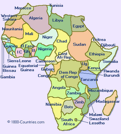
Mt. Kenya is Africa's second-highest peak, and is located less than one degree south of the equator. Its two highest points, Nelion and Batian, are only accessible to rock climbers. We thought about bringing a rope and our climbing gear, but we thought that it wasn't worth lugging all that stuff around Africa for two months, when we'd only be using it for two days. And we couldn't find a reliable and inexpensive way of shipping our gear to Kenya. So, like 99% of the other people on the mountain, we settled for trekking to the third-highest peak, Pt. Lenana at 4985m, some 200m below the true summit. However, unlike most visitors to the mountain, we decided to do it without a guide or porters, (part of our penance of having the luxury of having them on Mt. Kilimanjaro). We also decided we'd do an east to west traverse of the mountain, starting in the village of Chogoria and ending some 85km later in the village of Naro Moru. So with huge packs full of clothes for wind, rain and cold, camping gear, and a week's worth of food, we set out. This was going to be "No Picnic on Mt. Kenya" for us, too!
Actually, the afternoon before we left we were rocked by an earthquake in Chogoria! After experiencing a magnitude 6.8 quake in Hawaii last October before Ironman, we're getting a bit tired of being hit by quakes every time we go on holiday! It's actually not too surprising we felt a quake here, as Chogoria is on the edge of the Rift Valley, and on the edge of a tectonic plate, where quakes are quite prevalent. We're taking our next holiday in the middle of a tectonic plate - Saskatchewan sounds good!
Our first day involved a 27km slog up a muddy track through dense jungle and then through bamboo forest. This would have been quite pleasant, except for the eight hours of rain we had during the hike! We were cold, tired and wet by the time we got to our camping spot. When we found that there were wooden cabins available, there was no question about camping - we opted for drying out and warming up by the fire in the cabin!
On the second day we hike 14km along a ridge. Unfortunately it was very misty so we only got the occasional tantalizing glimpse of the stunning views. But we were just happy it wasn't raining! As we reached our campsite for the night at Hall Tarns we climbed above the mist and were treated to spectacular mountain scenery.
We took a rest/acclimatization day at 4300m at Hall Tarn's and explored the surrounding area, including peering over the vertigo-inducing 300m cliff of The Temple down to one of Mt. Kenya's deep valleys.
The following day we climbed up steep scree and over Tooth Col at 4700m then across a precipitous scree slope to the Austrian Hut. We felt we were really in the mountains this day. It was cool hanging out at the Austrian Hut area as we'd read so much about it during our climbing days. The scenery was spectacular with the main summits just across the Lewis Glacier. We had to go and stand on a glacier at the equator!
Most people get up well before dawn to be at Pt. Lenana for sunrise. Having seen plenty of sunrises, we chose the civilized option and climbed in the light. It was much warmer and we had the summit to ourselves when we reached it at 8:00 a.m. We spent a glorious 30 minutes on the summit in cloudless, windless conditions admiring the views on all sides. Later that day we packed up our tent and descended 2000m down through the glacier-scoured Teleki Valley through forests of giant groundsel. We didn't quite escape the day without getting wet; as we descended the notorious "vertical bog" a hailstorm hit us and the bog turned into a river. This was a sting in the tail to a very long, tough day. Fortunately it cleared up within an hour and we had sunshine to finish the day.
The trek wasn't over yet; we had a further 23km to hike to the village of Naro Moru, however the going was much easier, most of it on a 4WD track (and in the sunshine!). We descended through bamboo and cloud forest where we saw plenty of fresh elephant and buffalo dung, but the animals remained elusive. When we reached our hotel in Naro Moru we celebrated with huge plates of chips and cold Tusker beers. Tired, stiff and a little sunburned, we felt like we'd just done an Ironman! This trip was way harder than climbing Mt. Kilimanjaro but it felt much more rewarding. No picnic indeed!
Next stop, Uganda!
 Our campsite nestled among the Giant Groundsel by Hall Tarn (4300m). The spires of Mt Kenya ridges behind. Finally some clear sunny weather!
 You can just make out Chris on top of the cliff of the Temple along the Chogoria route on the slopes of Mt Kenya.

Chris at our campsite at the Austrian Hut (4800m) with the summit spires Nelion and Batian of Mt Kenya behind.

Glacier at the equator! Zoe on Lewis Glacier (4800m) below Nelion spire on Mt Kenya.


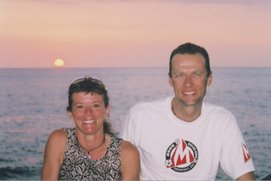
Zoe & Chris with the Kenyan flag at Point Lenana (4985m), the highest point we reached on Mt. Kenya. The true summit, Batian is some 200m higher and is the spire behind us but requires technical rock climbing to reach.

Chris starting the descent down from the Austrian Hut with our exit route from Mt Kenya, the Naro Moru route, going down the Teleki Valley behind.
Mt. Kenya is Africa's second-highest peak, and is located less than one degree south of the equator. Its two highest points, Nelion and Batian, are only accessible to rock climbers. We thought about bringing a rope and our climbing gear, but we thought that it wasn't worth lugging all that stuff around Africa for two months, when we'd only be using it for two days. And we couldn't find a reliable and inexpensive way of shipping our gear to Kenya. So, like 99% of the other people on the mountain, we settled for trekking to the third-highest peak, Pt. Lenana at 4985m, some 200m below the true summit. However, unlike most visitors to the mountain, we decided to do it without a guide or porters, (part of our penance of having the luxury of having them on Mt. Kilimanjaro). We also decided we'd do an east to west traverse of the mountain, starting in the village of Chogoria and ending some 85km later in the village of Naro Moru. So with huge packs full of clothes for wind, rain and cold, camping gear, and a week's worth of food, we set out. This was going to be "No Picnic on Mt. Kenya" for us, too!
Actually, the afternoon before we left we were rocked by an earthquake in Chogoria! After experiencing a magnitude 6.8 quake in Hawaii last October before Ironman, we're getting a bit tired of being hit by quakes every time we go on holiday! It's actually not too surprising we felt a quake here, as Chogoria is on the edge of the Rift Valley, and on the edge of a tectonic plate, where quakes are quite prevalent. We're taking our next holiday in the middle of a tectonic plate - Saskatchewan sounds good!
Our first day involved a 27km slog up a muddy track through dense jungle and then through bamboo forest. This would have been quite pleasant, except for the eight hours of rain we had during the hike! We were cold, tired and wet by the time we got to our camping spot. When we found that there were wooden cabins available, there was no question about camping - we opted for drying out and warming up by the fire in the cabin!
On the second day we hike 14km along a ridge. Unfortunately it was very misty so we only got the occasional tantalizing glimpse of the stunning views. But we were just happy it wasn't raining! As we reached our campsite for the night at Hall Tarns we climbed above the mist and were treated to spectacular mountain scenery.
We took a rest/acclimatization day at 4300m at Hall Tarn's and explored the surrounding area, including peering over the vertigo-inducing 300m cliff of The Temple down to one of Mt. Kenya's deep valleys.
The following day we climbed up steep scree and over Tooth Col at 4700m then across a precipitous scree slope to the Austrian Hut. We felt we were really in the mountains this day. It was cool hanging out at the Austrian Hut area as we'd read so much about it during our climbing days. The scenery was spectacular with the main summits just across the Lewis Glacier. We had to go and stand on a glacier at the equator!
Most people get up well before dawn to be at Pt. Lenana for sunrise. Having seen plenty of sunrises, we chose the civilized option and climbed in the light. It was much warmer and we had the summit to ourselves when we reached it at 8:00 a.m. We spent a glorious 30 minutes on the summit in cloudless, windless conditions admiring the views on all sides. Later that day we packed up our tent and descended 2000m down through the glacier-scoured Teleki Valley through forests of giant groundsel. We didn't quite escape the day without getting wet; as we descended the notorious "vertical bog" a hailstorm hit us and the bog turned into a river. This was a sting in the tail to a very long, tough day. Fortunately it cleared up within an hour and we had sunshine to finish the day.
The trek wasn't over yet; we had a further 23km to hike to the village of Naro Moru, however the going was much easier, most of it on a 4WD track (and in the sunshine!). We descended through bamboo and cloud forest where we saw plenty of fresh elephant and buffalo dung, but the animals remained elusive. When we reached our hotel in Naro Moru we celebrated with huge plates of chips and cold Tusker beers. Tired, stiff and a little sunburned, we felt like we'd just done an Ironman! This trip was way harder than climbing Mt. Kilimanjaro but it felt much more rewarding. No picnic indeed!
Next stop, Uganda!


Chris at our campsite at the Austrian Hut (4800m) with the summit spires Nelion and Batian of Mt Kenya behind.

Glacier at the equator! Zoe on Lewis Glacier (4800m) below Nelion spire on Mt Kenya.


Zoe & Chris with the Kenyan flag at Point Lenana (4985m), the highest point we reached on Mt. Kenya. The true summit, Batian is some 200m higher and is the spire behind us but requires technical rock climbing to reach.
Chris starting the descent down from the Austrian Hut with our exit route from Mt Kenya, the Naro Moru route, going down the Teleki Valley behind.